... to be in a Nationally acknowledged disaster area. It's not a good sign when local coverage of what's happening around town is going on all day. And we have been watching it as it unfolds all up and down the Front Range.
My family and I are basically on a peninsula, cut off to the North, South, and West by destroyed or underwater roads. For a little while we were cut off to the East as well, when I-25 and highway 85 were closed, it was impossible to get to or leave Longmont for a little while yesterday. The St. Vrain River cuts us off to the North from the rest of Longmont, to the south Boulder "Creek" cut off a lot of Boulder from the rest of Denver to the south.
Jet's school was closed Thursday for a Flood Day, and then we found out, on Friday that they were going to remain closed through next Wednesday, the 18th. So we just stayed at home, put away jugs of water, watched TV, ate our plentiful supplies, listened to helicopters going into and out of Longmont's airport, and just stayed safe. Until yesterday morning, when the sun actually came out for a little while and we went exploring on our bikes, not on cars that could be a nuisance for the emergency vehicles that were being deployed all over town.
 It was beautifully sunny Friday morning, so we went out on a bike ride, and found dozens and dozens of people out to see what was going on around town, too. They all pretty much had the same idea we did, which was to stay out of vehicles that would mess up rescue crews and the like, and get a little exercise after begin cooped up in the house for a Flood Day out of school.
This was two neighborhoods over, where there was a "small creek" that was by a small scenic walking path that connected two neighboring areas. This is the walking path, with the trash can on the way to the foot bridge that was completely underwater.
There was a guy there, taking pictures in his bare feet, as he waded up and down where the sidewalks used to be. He told us that he'd been asked to evacuate, and he'd refused. They were fine, high enough up from the creek itself to escape the water. Normally, this creek isn't even noticeable, and it's often dry this time of year, nothing but a trickle. This monster was eating houses on its edges, and we just stood there and boggled.
 You can see here just how beautiful a day it was, and we encountered our first real sign of the times, with the closure of Airport Road. It's our main access to the north part of town, and we go this way all the time, and to see it closed was a big thing.
All the North-South routes through down were closed because of the St. Vrain river running over, undercutting, and destroying as it went from the mountains in the west to the plains of the East (where a lot of the flooding got really bad today as the water suddenly caught up with all the towns out there). So we were pretty much cut off from our Old Town and downtown, as well as our church.
You can also see another couple on the sidewalk coming toward us, and another family rode by us on their bikes as we were taking pictures. John and I each had a camera. *laughs*
 This is usually another trickle stream, with a bed that meanders across a rather level, broad plain, with lots of little trees on it, that they were trying to grow with native grasses to fix the banks a little better.
 Most of those trees are now underwater, and the path to the right was closed to traffic. It goes to Golden Ponds, where I painted that Longs Peak painting in the spring. The path meanders pretty close to the stream, so I suspect a lot of it was not only underwater, but a section that was relatively low was probably washed out.
So we didn't go that way, though I was highly curious, both John and I decided it was better to just respect the closure.
 The irrigation ditches were serving double duty, now, as controlled outlets for the waters that were raging through. I've never seen this one this full before, at complete capacity and roaring away into the fields and trees that could handle it.
It was pretty amazing standing on the grate and feeling the power of the thing as it burst away.
 Right when we pulled up, Longmont Fire was helping this family out. Not sure exactly what happened, but the water was flowing pretty fast across the section of Airport that was underwater.
Thing is that right to the left of this road block was the Longmont Road crew supply depot, where they had all their sand, trucks, and things for maintaining and working the roads throughout town, so we kept seeing trucks going in and out of the area to the left, through some of the deep puddles, and over the roads that were under a few inches of water to get to all the things that the road guys usually use for road repair.
 And here is one off shoot of the Mighty St. Vrain.
John, Jet, and I used to mock the name. It was pretty much a creek, most of the time, and compared to the Mighty Columbia, which is utterly enormous, the idea of the St. Vrain River getting called a river even seemed ridiculous.
Until now.
This is just the southmost of at least three branches here at Airport.
About an hour ago, this is what one of the northern branches looked like:

It's flooding 9th Ave, which is our usual turn to the East for our church. The neighborhood to the north of it housed three families that we knew really well, and it's all underwater. It's a little insane knowing the houses in that picture. We're gearing up to help them pump out basements, lift carpet, replace walls, and get things dried up as soon as the rains really stop.
 This shed and the floating pumpkins are from a little farm that we often buy produce from, and they even have their own hives. Zweck's stand is pretty much right next to the river, and I wonder if it's even there anymore.
I found out, when I got home, that one of the local keepers, who has been instrumental in getting bees every spring for the BCBA, lost six yards, and over 100 hives in the last three days. Just drowned out, poor girls. So we're all volunteering to help clean out equipment, bring splits in the spring, and do what we can to help him recover his losses. Miles has helped out everyone in the community so it seems crazy not to help him out as well, after.
 I'll admit that it was kind of surreal, since it was SUCH a beautiful day on Friday. There were dozens of people out walking, biking, jogging, and getting their dogs out, and then there were scenes like this, with more water than we normally see in a year all on the ground all around us.
The rush of it, even in the street, was just amazing. And it was so beautiful out, with the clouds looking puffy and harmless on the horizon. So we decided to just go look a little more, through one of the local parks, the Barn Park, that we knew had a stream running through it.
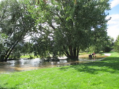 Now the creek was running through part of the park, too, not just beside it.
That was pretty amazing, especially where we could see the water going AROUND its bed to other places all around it. But the road at the far side was just fine, and we made our way home pretty easily.
It was just really strange, kind of a touring view of the borders of what we could see. Some of the aerial footage was pretty amazing, especially the planes that followed the St. Vrain from Lyons (which was nearly completely washed away) down to Longmont, and you can see the spread of water all along the more southern parts of Airport.
It's a little strange.
Still getting my heart around how much of the town is actually underwater, and I hear thunder outside my window and the light fall of rain. I'm hoping it isn't too bad, but everyone's been braced for tonight's last storm. There's more to come tomorrow, but by Monday we should be drying out, the rain should stop.
The difference with these rains compared to the usual ones, is that MOST of our weather comes from the West. It's clouds brought from the Pacific by the Jet Stream, and they get pushed up against the mountains and wrung out before they head over here. So there is rarely much moisture to drop on this side of the mountains from the prevailing winds.
The craziness of all this is that there was a long-lasting low to the East of us, and it was rotating clockwise and pulling moist air from the Gulf and bringing a stream of that from south to north, with just enough of a push west to shove the clouds against the east side of the mountains. That same compaction from being pushed up against the mountains caused the clouds to release all their rain and whooosh, lots and lots of water. In the winter, when this usually happens, we call it an Upslope storm, and we get feet of snow out of it, even when the clouds are dessicated by the cold.
This was just unprecedented. Upslope early and warm, so the clouds were just loaded. Today Aurora got feet of hail, on top of the rain, and they were shoveling their way out of it. Only in Colorado.
I think we'll be just fine, but I am worried about the additional damage to those who have already taken so much damage. All the neighborhoods but one were allowed back into their homes today, so I think the officials aren't as worried as we are about the predicted rain amounts. We'll see in the morning.
My family and I are basically on a peninsula, cut off to the North, South, and West by destroyed or underwater roads. For a little while we were cut off to the East as well, when I-25 and highway 85 were closed, it was impossible to get to or leave Longmont for a little while yesterday. The St. Vrain River cuts us off to the North from the rest of Longmont, to the south Boulder "Creek" cut off a lot of Boulder from the rest of Denver to the south.
Jet's school was closed Thursday for a Flood Day, and then we found out, on Friday that they were going to remain closed through next Wednesday, the 18th. So we just stayed at home, put away jugs of water, watched TV, ate our plentiful supplies, listened to helicopters going into and out of Longmont's airport, and just stayed safe. Until yesterday morning, when the sun actually came out for a little while and we went exploring on our bikes, not on cars that could be a nuisance for the emergency vehicles that were being deployed all over town.
This was two neighborhoods over, where there was a "small creek" that was by a small scenic walking path that connected two neighboring areas. This is the walking path, with the trash can on the way to the foot bridge that was completely underwater.
There was a guy there, taking pictures in his bare feet, as he waded up and down where the sidewalks used to be. He told us that he'd been asked to evacuate, and he'd refused. They were fine, high enough up from the creek itself to escape the water. Normally, this creek isn't even noticeable, and it's often dry this time of year, nothing but a trickle. This monster was eating houses on its edges, and we just stood there and boggled.
All the North-South routes through down were closed because of the St. Vrain river running over, undercutting, and destroying as it went from the mountains in the west to the plains of the East (where a lot of the flooding got really bad today as the water suddenly caught up with all the towns out there). So we were pretty much cut off from our Old Town and downtown, as well as our church.
You can also see another couple on the sidewalk coming toward us, and another family rode by us on their bikes as we were taking pictures. John and I each had a camera. *laughs*
So we didn't go that way, though I was highly curious, both John and I decided it was better to just respect the closure.
It was pretty amazing standing on the grate and feeling the power of the thing as it burst away.
Thing is that right to the left of this road block was the Longmont Road crew supply depot, where they had all their sand, trucks, and things for maintaining and working the roads throughout town, so we kept seeing trucks going in and out of the area to the left, through some of the deep puddles, and over the roads that were under a few inches of water to get to all the things that the road guys usually use for road repair.
John, Jet, and I used to mock the name. It was pretty much a creek, most of the time, and compared to the Mighty Columbia, which is utterly enormous, the idea of the St. Vrain River getting called a river even seemed ridiculous.
Until now.
This is just the southmost of at least three branches here at Airport.
About an hour ago, this is what one of the northern branches looked like:
It's flooding 9th Ave, which is our usual turn to the East for our church. The neighborhood to the north of it housed three families that we knew really well, and it's all underwater. It's a little insane knowing the houses in that picture. We're gearing up to help them pump out basements, lift carpet, replace walls, and get things dried up as soon as the rains really stop.
I found out, when I got home, that one of the local keepers, who has been instrumental in getting bees every spring for the BCBA, lost six yards, and over 100 hives in the last three days. Just drowned out, poor girls. So we're all volunteering to help clean out equipment, bring splits in the spring, and do what we can to help him recover his losses. Miles has helped out everyone in the community so it seems crazy not to help him out as well, after.
The rush of it, even in the street, was just amazing. And it was so beautiful out, with the clouds looking puffy and harmless on the horizon. So we decided to just go look a little more, through one of the local parks, the Barn Park, that we knew had a stream running through it.
That was pretty amazing, especially where we could see the water going AROUND its bed to other places all around it. But the road at the far side was just fine, and we made our way home pretty easily.
It was just really strange, kind of a touring view of the borders of what we could see. Some of the aerial footage was pretty amazing, especially the planes that followed the St. Vrain from Lyons (which was nearly completely washed away) down to Longmont, and you can see the spread of water all along the more southern parts of Airport.
It's a little strange.
Still getting my heart around how much of the town is actually underwater, and I hear thunder outside my window and the light fall of rain. I'm hoping it isn't too bad, but everyone's been braced for tonight's last storm. There's more to come tomorrow, but by Monday we should be drying out, the rain should stop.
The difference with these rains compared to the usual ones, is that MOST of our weather comes from the West. It's clouds brought from the Pacific by the Jet Stream, and they get pushed up against the mountains and wrung out before they head over here. So there is rarely much moisture to drop on this side of the mountains from the prevailing winds.
The craziness of all this is that there was a long-lasting low to the East of us, and it was rotating clockwise and pulling moist air from the Gulf and bringing a stream of that from south to north, with just enough of a push west to shove the clouds against the east side of the mountains. That same compaction from being pushed up against the mountains caused the clouds to release all their rain and whooosh, lots and lots of water. In the winter, when this usually happens, we call it an Upslope storm, and we get feet of snow out of it, even when the clouds are dessicated by the cold.
This was just unprecedented. Upslope early and warm, so the clouds were just loaded. Today Aurora got feet of hail, on top of the rain, and they were shoveling their way out of it. Only in Colorado.
I think we'll be just fine, but I am worried about the additional damage to those who have already taken so much damage. All the neighborhoods but one were allowed back into their homes today, so I think the officials aren't as worried as we are about the predicted rain amounts. We'll see in the morning.
Comments
Post a Comment